Daily outlook
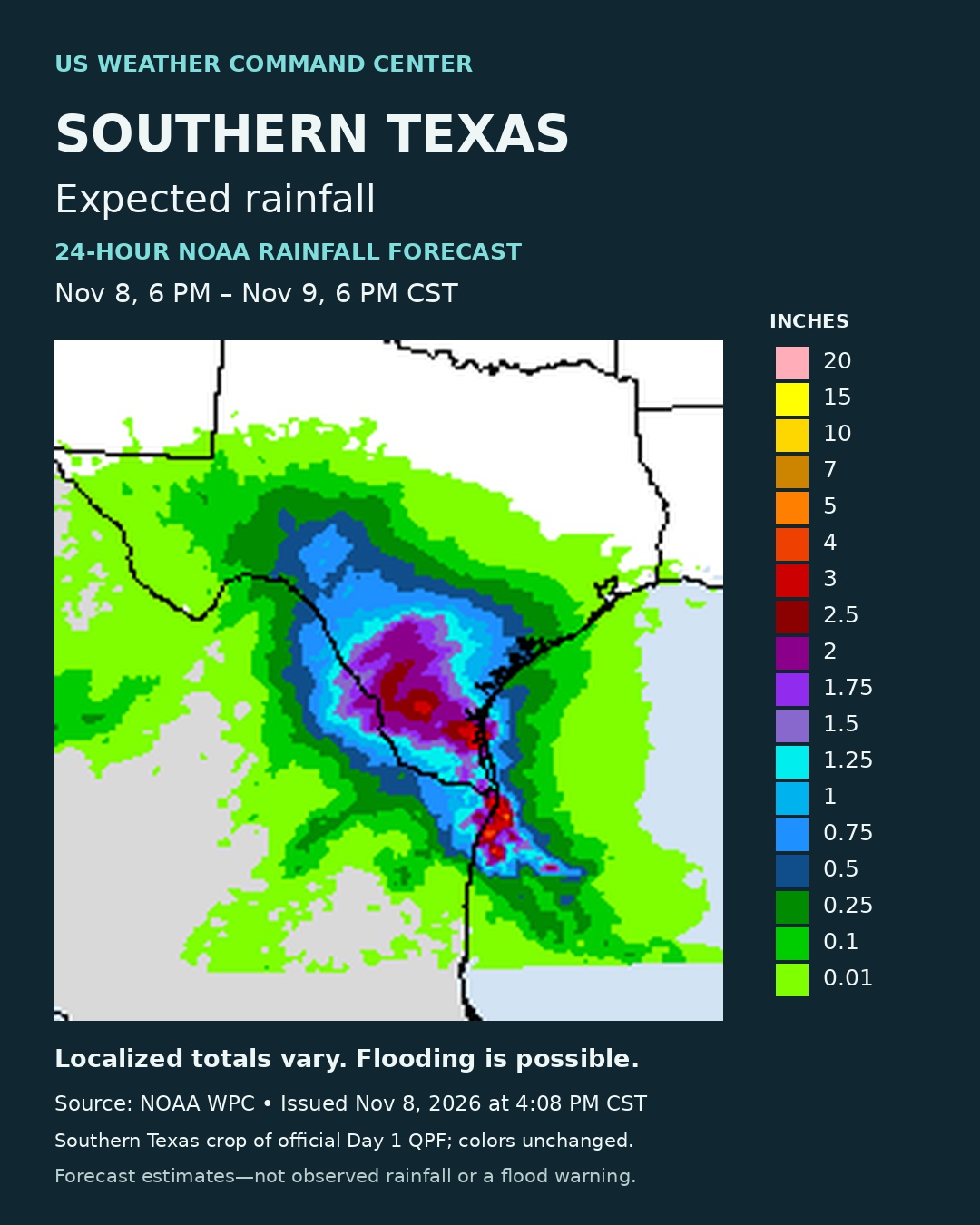
Heavy rainfall and flash flood threat peaks across southern Texas today into Monday morning
Heavy rainfall and flash flood threat peaks across southern Texas today into Monday morning Active Pacific storm track will bring periods of rain to the Pacific Northwest through the next couple of days Conditions across the country will continue trending mild to unseasonably warm following one more chilly night in the Southeast
National outlook · 1
A passing upper-wave and an influx of anomalously moist air from the Gulf will continue to lead to scattered to widespread thunderstorms across portions of southern to south-central Texas today. Locally very heavy downpours producing several inches of rainfall could lead to some scattered instances of flash flooding, and a Slight Risk of Excessive Rainfall (level 2/4) is in effect. Storms will linger into Monday with some additional isolated instances of flash flooding possible. To the northwest, a series of Pacific storm systems will bring periods of moderate rain and some higher elevation snow to the Pacific Northwest through the next few days. The most widespread/heaviest precipitation is expected later Monday and Monday night. Elsewhere, a couple passing low pressure system will bring some scattered showers to portions of the Upper Great Lakes and Interior Northeast. Otherwise, the rest of the country should be mostly dry.
National outlook · 2
Another chilly night is forecast across portions of the Ohio and Tennessee Valleys and into portions of the Southeast as dry conditions lead to Monday morning lows dropping into the 30s, and Frost Advisories remain in effect. However, temperatures overall across the country continue to look mild to unseasonably warm as we wrap up the weekend and move into the first part of this week. Forecast highs are generally in the 50s and 60s across the northern tier, the 60s and 70s across the southern tier, and into the 80s for southern California/the Desert Southwest as well as Florida. Temperatures remain relatively cooler across southern/western Texas today and into portions of the Southwest as clouds and precipitation linger through the region, with highs in the 60s and even some 50s. However, temperatures over the next couple of days will trend upward there as well.
Sources & issue dates
Source links show the latest discussion and may differ from the dated issues used for this article.
- NOAA WPC Short Range Forecast Discussion
Issued 214 PM EST Sun Nov 8 2026